
Sutherland Shire's waterways are an important part of the local environment, supporting native plants and animals, improving water quality, and providing places for recreation and connection with nature. From creeks and wetlands to rivers and estuaries, these waterways are constantly changing and require ongoing care to remain healthy and resilient.
Our aim
'We aim to safeguard and enrich our natural waterways, while educating future generations on the vital importance of maintaining their health and biodiversity'
Healthy waterways support local wildlife, improve water quality and provide places for the community to enjoy nature. As Sutherland Shire continues to grow, these waterways face increasing pressures from urban development, erosion, pollution and loss of habitat.
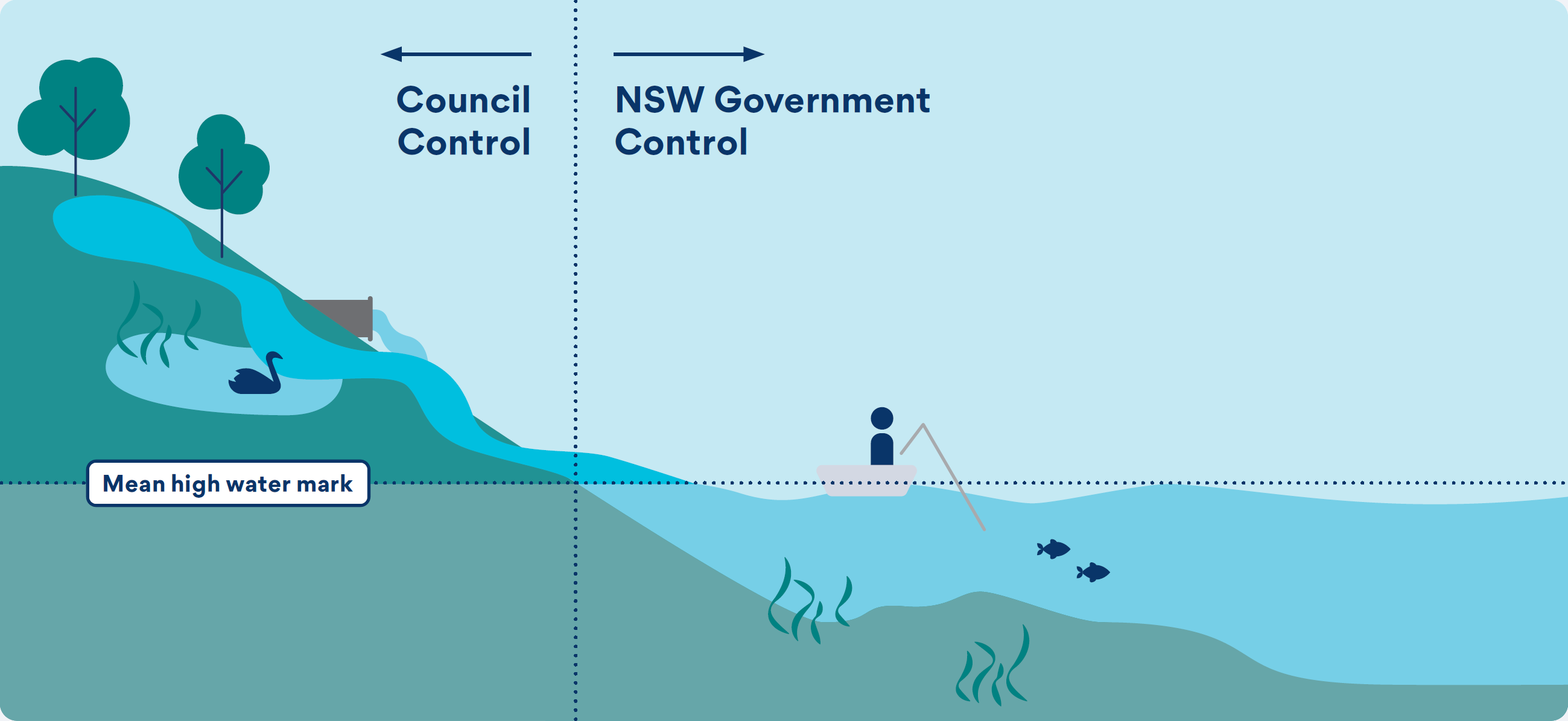
In general, we manage activities that affect waterways from the surrounding land and catchment areas, while NSW Government agencies are responsible for waterways and waterbodies below the mean high-water mark. We work closely with these agencies and may undertake works on their behalf where approvals and funding are available.
The diagram below explains where responsibilities generally apply across Sutherland Shire's waterways.
How We Manage Our Waterways
Guided by our Catchment & Waterways Strategy, we work to protect and improve the health of our creeks, wetlands, rivers and estuaries. We do this through water quality improvement projects, rehabilitation works, environmental monitoring, wetland management and community education programs.
Healthy catchments help create healthy waterways. Litter, sediment, nutrients and other pollutants can be washed into waterways during rainfall, affecting water quality and the plants and animals that rely on these environments.
We work to improve catchment health by reducing pollution, maintaining stormwater treatment systems and monitoring water quality across the Shire. This helps protect biodiversity and improve the health of our creeks, wetlands, rivers and estuaries.
Our Clean Catchments Program is being developed to improve the health of local waterways by reducing litter, sediment and other pollutants before they reach creeks, rivers, wetlands and estuaries.
Council currently prevents around 1,010 tonnes of litter and debris from entering waterways each year through stormwater treatment devices. The program will build on this work by identifying pollution hotspots, improving stormwater treatment infrastructure and helping achieve Council's targets of a 60% reduction in litter from urban catchments by 2030 and a 90% reduction in litter from high-polluting catchments by 2035.
Supporting this work, our Zero Litter to Ocean Campaign is being developed to help reduce pollution at its source by increasing community awareness and encouraging actions that prevent litter and other pollutants from entering the stormwater network and local waterways.
Related Programs
- Zero Litter to Ocean Campaign (Targeted Commencement 2028)
- Clean Catchments Program - Stage 1 Under development (Targeted completion - Mid 2028)
- Clean Catchments Program - Stage 2 (Targeted completion - Mid 2030)
- Strategic Water Monitoring Program (SWaMP) & Annual Report Cards
Creeks, waterways and the surrounding riparian corridors provide important habitat for native plants and animals. Over time, erosion, weed invasion, pollution and urban development can affect the health of these waterways and the ecosystems they support.
We work to restore and improve waterways through activities such as weed removal, native planting, erosion control and habitat restoration. These works help protect biodiversity, improve water quality and support healthier waterways across the Shire.
The Watercourse Assessment and Rehabilitation Prioritisation Study guides our Waterways Rehabilitation Program by identifying waterways that would benefit most from restoration works. Completed in 2012, the study is coming up for review and set to be completed in Mid 2034. This review will determine its effectiveness assessing completed works, identifying any remaining actions and determine future rehabilitation priorities
Watercourse Assessment and Rehabilitation Prioritisation Study
- Overview of WARP Study
- Botany Bay Catchment Profile
- Georges River Catchment Profile
- Hacking River Catchment Profile
- Pacific Ocean Catchment Profile
- Port Hacking Catchment Profile
- Woronora River Catchment Profile
In 2025, the Georges River Estuary NEAP Bank Erosion and Riparian Condition Assessment Report provided detailed information on riverbank stability and riparian vegetation condition. This information will help guide future rehabilitation and waterway management activities.
Related Programs
- Natural wetlands help filter sediment and nutrients, regulate water flow and support a wide range of aquatic species.
- Constructed wetlands are designed to mimic these natural processes, treating stormwater runoff and improving water quality before it enters local waterways.
Our Wetland Management Plan is being developed to guide the conservation, restoration and ongoing management of wetlands across Sutherland Shire. The plan will bring together existing wetland management plans and help prioritise future actions to protect these important ecosystems.
Related Programs
- Wetlands Management Plan (Targeted for Mid 2032)
- Burnum Burnum Wetland Management Plan & Appendix E
- Marton Park Wetland Management Plan
- Still Creek Wetland Management Plan
The management of Sutherland Shire's estuaries and tidal waterways is guided by the NSW Coastal Management Framework. Through Coastal Management Programs, we work with government agencies and the community to protect and manage the Georges River (including the Woronora River), Port Hacking and Bate Bay.
For more information on this visit our Coastal Management page.
Dredging may also be considered in some waterways to support navigation, waterway access and the functioning of infrastructure. Under Council's Dredging Policy, responsibility for dredging generally rests with the NSW Government where it owns the waterway bed, although Council may undertake works on its behalf where appropriate approvals and funding are available.
A Dredging Assessment and Prioritisation Plan will be developed developed to help identify and prioritise locations where dredging may be required to support navigation, waterway access and infrastructure. The plan will use a risk-based approach to assess dredging needs, inform future funding applications and guide long-term management, in line with our Dredging Policy. Any dredging activities must carefully consider environmental impacts and protect sensitive habitats such as seagrass beds and seahorse habitat.
Related Programs & Plans
- Dredging Assessment & Prioritisation Plan (Targeted for Mid 2032)
- Dredging Policy
- Woronora River Dredging Management Plan
- Oyster Bay Dredging Management Plan (Appendix to the Oyster Bay Waterways Management Plan)
Existing management programs and plans
Over many years, we have developed a range of studies, management plans and programs to better understand, protect and improve waterways across Sutherland Shire. These documents continue to guide on-ground works and management actions today, while informing the development of future plans, programs and projects.

Forbes Creek rehabilitation works completed in 2020, guided by the Watercourse Assessment and Rehabilitation Prioritisation Study. This study continues to inform waterway rehabilitation priorities and future management actions across the Shire.
- Bundeena Creek Management Plan *
- Ewey Creek Management Plan *
- Gunnamatta Bay Contaminated Sediment Study *
- Gymea Bay Estuary Management Plan *
- North West Arm Coastal Zone Management Plan *
- Oyster Bay Waterways Management Plan & Dredging Management Plan
- Port Hacking Integrated Environmental Management Plan * & Bibliography
- Port Hacking - Past and Present of an Estuarine Environment *
- Woronora Estuary Management Plan
- Woronora River Dredging Management Plan
- Yowie Bay Estuary Management Study & Plan *
Useful links
- Greenweb - a program encouraging native planting, weed control and landscaping on private properties to help establish and connect bush and waterway corridors.
- Bushcare - community volunteers caring for over 120 bushland reserves across Sutherland Shire.
- Georges Riverkeeper - advocates for the protection, conservation and enhancement of the health of the Georges River.